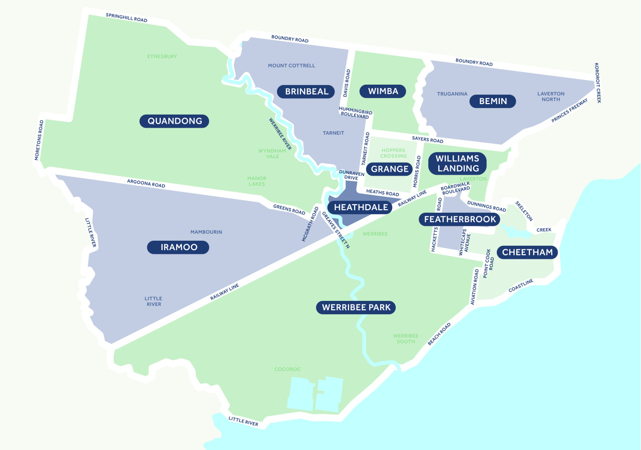
Bemin
Bemin Ward includes parts of Truganina and Laverton North. It is bounded by Skeleton Creek, Sayers Road, Old Geelong Road and Boundary Road. It covers an area of 39.6 square kilometres. As of July, 2023, it had 16,356 registered electors.
Brinbeal
Brinbeal Ward includes parts of Mount Cottrell and Tarneit. It is bounded by Boundary Road, Werribee River, Hummingbird Boulevard and Tarneit Road. It covers an area of 41.7 square kilometres. As of July, 2023, it had 18,150 registered electors.
Cheetham
Cheetham Ward covers an area of 21.4 square kilometres in Point Cook. It is bounded by Point Cook Road, Sneydes Road, Mercure Way and Whitecross Avenue, and the coastline. As of July, 2023, it had 17,160 registered electors.
Featherbrook
Featherbrook Ward is also in Point Cook. As of July, 2023, it contained 18,079 registered electors. The Ward is bounded by Hacketts Road, Skeleton Creek, Boardwalk Boulevard, Point Cook Road and Sneydes Road. It covers an area of 8.8 square kilometres.
Grange
The Grange Ward is located in Hoppers Crossing. It is bounded by Tarneit Road, Heaths Road, Morris Road, Sayers Road and Tamborine Avenue. It covers an area of 10.7 square kilometres. As of July, 2023, it had 17,117 registered electors.
Heathdale
Located in Werribee, the Heathdale Ward covers an area of 10.2 square kilometres. It is bounded by the Werribee River, Dunraven Drive, Heaths Road, Morris Road, Greaves Street North and the railway line. As of July 2023, it had 17,920 registered voters.
Iramoo
Bounded by Argoona Road, Greens Road, Greaves Street North and Little River, Iramoo Ward is located within Werribee, Kittle River and Mambourin. It covers 95.1 square kilometres. As of July 2023, there were 18,120 registered electors.
Quandong
Quandong Ward is bounded by Argoona Road, Greens Road, Werribee River, Moretons Road and Spring Hill Road and covers the suburbs of Quandong, Eynesbury, Manor Lakes and Wyndham Vale. It has an area of 125.3 square kilometres. As of July 2023, it had 18,458 registered voters.
Werribee Park
Werribee Park Ward covers the suburbs of Werribee, Cocoroc and Werribee South. It is the largest Ward by area, covering 152.5 square kilometres. It is bounded by the railway line, Hacketts Road, Aviation Road and coastline. As of July, 2023, it had 18,404 registered electors.
Williams Landing
The Williams Landing Ward covers 15.7 square kilometres. Covering the suburb of Williams Landing, it is bounded by Sayers Road, Morris Road, Skeleton Creek, Boardwalk Boulevard and Dunnings Road. As of July 2023, it had the highest number of electors – 19,178.
Wimba
Wimba Ward covers the suburbs of Tarneit and Truganina. It is bounded by Boundary Road, Davis Road, Hummingbird Boulevard, Tarneit Road, Sayers Road and Skeleton Creek. It covers an area of 20.5 square kilometres. As of July 2023, it had 17,996 electors.